Tuesday, May 28, 2013
Mid-Willamette Explorer is now up
My newest blog, featuring just the mid-Willamette Valley, is now posted. In a magazine format, the June issue is the first to be created. Check the nine articles out at Mid-Willamette Explorer
Native Talk Tuesday #10
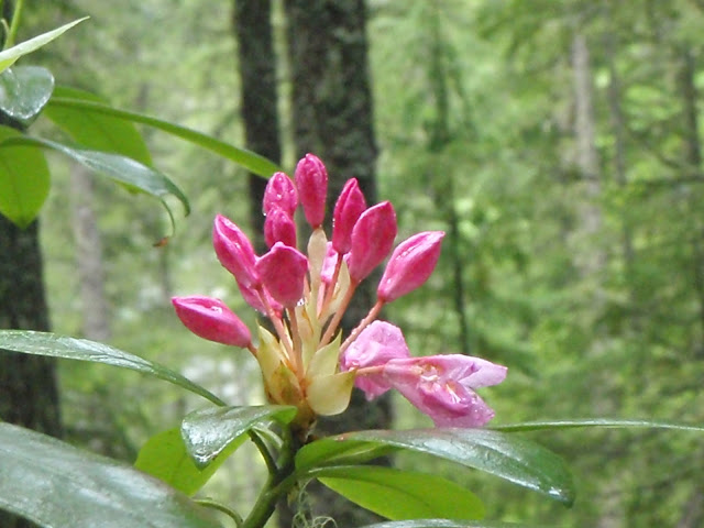
The plant featured in today's Native Talk Tuesday is Rododendron macrophyllum,
commonly known as the Pacific Rhododendron. This type of Rhododendron produces pink flowers from May to July, depending on elevation and latitude. Almost all Pacific Rhododendrons in the forests will be scraggly instead of the bushy rhododendrons seen in many yards across the Willamette Valley. This type of plant is found from the coast to middle elevations and range from northern California to the Canadian border.
 Although more widely spread in Oregon, the Pacific Rhododendron is the state flower of Washington. This species of rhododendron readily sprouts after a clear-cut or forest fire, bringing color to cleared or burned areas.

 Although more widely spread in Oregon, the Pacific Rhododendron is the state flower of Washington. This species of rhododendron readily sprouts after a clear-cut or forest fire, bringing color to cleared or burned areas.

Tuesday, May 21, 2013
Native Talk Tuesday #9
The plant featured in today's Native Talk Tuesday is Rosa nutkana,
commonly known as the Nootka Rose. For those that do not know the distinction between this rose and other wild roses, it is also refered to as the Wild Rose. Usually growing to 10 feet high, with soft, straight thorns at the base of each leaflet, this rose can sometimes be seen along the roadsides of the Willamette Valley. The leaflets, which alternate along the branches, contain 5 or 7 serrated leaves. The flowers are differentiated from the Baldhip Rose as they are larger, at 1.5 to 3 inches across. Unlike the Clustered Wild Rose, the Nootka Rose has only one flower at the end of each stem.

The Nootka Rose is often found in a variety of open habitats such as along the streambanks, clearings, meadows, thickets, and along roadsides of the Pacific Northwest from Southern Oregon to Glacier Bay, Alaska; occurring from low to middle elevations. This rose was named after one of several, if not many, native tribes who placed the leaves under and over their food to flavor it and keep it from burning while being cooked. Chewed leaves were applied to bee stings, and although I wouldn't recommend it, a tea made from strips of bark from this plant was used as an eyewash for cataracts or to enhance eyesight.


The Nootka Rose has pink, 5-petal flowers that are up to 3 inches across.
The Nootka Rose is often found in a variety of open habitats such as along the streambanks, clearings, meadows, thickets, and along roadsides of the Pacific Northwest from Southern Oregon to Glacier Bay, Alaska; occurring from low to middle elevations. This rose was named after one of several, if not many, native tribes who placed the leaves under and over their food to flavor it and keep it from burning while being cooked. Chewed leaves were applied to bee stings, and although I wouldn't recommend it, a tea made from strips of bark from this plant was used as an eyewash for cataracts or to enhance eyesight.

The Nootka Rose growing along a country road east of Salem.
Monday, May 20, 2013
Mountain View Monday #8
Across Diamond Lake from the main campground lies a volcano with a rounded top. Due to its gentle slope, compared to other Cascade stratovolcanoes, Mount Bailey is often traveled on in winter. Those who go to snowshoe, ski, or drive a snowmobile over its slopes, usually end up camping at the Diamond Lake resort.
Mount Baily is under 9,000 feet high and was a spiritual place for Native Americans, who were first credited with ascending the mountain. Even today, people still come to hike the mountain in summer.

Mount Baily is under 9,000 feet high and was a spiritual place for Native Americans, who were first credited with ascending the mountain. Even today, people still come to hike the mountain in summer.

Sunday, May 19, 2013
Earth Speak Sunday #8
 Leaves of Grass by Walt Whitman
Now I see the secret of the making of the best persons. It is to grow in the open air, and to eat and sleep with the earth.
Saturday, May 18, 2013
State Park Saturday #7
For those of you that live in or near Polk County, there is a small, often overlooked state park south of Monmouth. Known as Sarah Helmick State Park, this day-use park sits on more than 80 acres along the Little Luckiamute River. To get an idea of how Oregon's fist state park was created, we need to go back in time...

In 1846, after traveling from Iowa by wagon train, Sarah and Henry Helmick established a claim on the land that is now the park. Fast-forward 76 years, to February 15, 1922, 5 acres was donated to the state of Oregon by 'Grandma' Helmick and her son James. This gift to the people of Oregon was the first ever and was to be used for a park. Now back in those days, there was no Oregon Parks Division, so the money was given to the Oregon State Highway Commission (now known as ODOT) to create a park. Later on, additional land was acquired through the family members to bring the size of the park up to 30 acres. After two purchases, of which one was formerly part of an artillery range of Camp Adair used in WWII, the park became the size it is today.

Although this park once had campgrounds, camping is no longer allowed, unless you decide to become a park host. Two main picnic areas can be reserved and include a sheltered table with electricity for anything you want to plug in. Beside each of the group picnic areas, is a restroom, and short trails lead down to the river. As the trails get close to the water, steps have been carved into the sand along the steep riverbanks.

So if you plan on going to Sarah Helmick State Park, bring your dog along as this is one park Fido can enjoy, as long as he/she is wearing a leash. Although it doesn't say on the sign entering the park, fishing is allowed. Until next Saturday, get outside and enjoy one of the many state parks in the great Oregon Outdoors.

A short trail guides visitors to the Luckiamute River
In 1846, after traveling from Iowa by wagon train, Sarah and Henry Helmick established a claim on the land that is now the park. Fast-forward 76 years, to February 15, 1922, 5 acres was donated to the state of Oregon by 'Grandma' Helmick and her son James. This gift to the people of Oregon was the first ever and was to be used for a park. Now back in those days, there was no Oregon Parks Division, so the money was given to the Oregon State Highway Commission (now known as ODOT) to create a park. Later on, additional land was acquired through the family members to bring the size of the park up to 30 acres. After two purchases, of which one was formerly part of an artillery range of Camp Adair used in WWII, the park became the size it is today.

A secluded picnic area overlooks the Luckimute River
Although this park once had campgrounds, camping is no longer allowed, unless you decide to become a park host. Two main picnic areas can be reserved and include a sheltered table with electricity for anything you want to plug in. Beside each of the group picnic areas, is a restroom, and short trails lead down to the river. As the trails get close to the water, steps have been carved into the sand along the steep riverbanks.

Big Leaf Maples tower over the picnic areas
So if you plan on going to Sarah Helmick State Park, bring your dog along as this is one park Fido can enjoy, as long as he/she is wearing a leash. Although it doesn't say on the sign entering the park, fishing is allowed. Until next Saturday, get outside and enjoy one of the many state parks in the great Oregon Outdoors.
Thursday, May 16, 2013
Trail Talk Thursday #9
Canyon Trail
This 3.9-mile trail takes you from South Falls through the canyon, hence its name, to North Falls. From the South Falls, instead of going back up to the lodge, this trail takes you along the South Fork of Silver Creek until you get to Lower South Falls. At this point along the trail, a series of switchbacks that are mostly stairs lead you deeper into the canyon and under the waterfall, much like South Falls, except there is a stone wall instead of a fence. If you were to come during Winter or early Spring, you would find a bit of water flooding the pathway behind Lower South Falls up to a few inches deep. Continuing on down the trail will bring you to the intersection with the Maple Ridge Trail, roughly 1 mile from the bridge below South Falls. At this intersection, there is a trail sign and bench that allows hikers to decide which way they want to go, and to rest if necessary. For those that are getting tired, it is recommended that you go back via the Maple Ridge Trail.

Lower South Falls
From this intersection, the Canyon Trail dips into the North Canyon alongside the North Fork of Silver Creek. At roughly three-quarters of a mile from the intersection, a bridge will take hikers across to the other side. At this spot, fishermen come to try their luck at getting small Brook Trout is summer. Just upstream is Lower North Falls, a favorite in Autumn for the multi-colored Vine Maples that go perfectly with the 30-foot cascade.

Lower North Falls
As you travel past the Lower North Falls, there is an additional 0.2-mile round trip hike along Hullt Creek that brings you to Double Falls, the only waterfall in the park that is split in two by a ledge, creating a double waterfall. This waterfall also has another claim to fame, being that it is the tallest waterfall in the park at 177 feet high.

Double Falls
From Hullt Creek to the intersection with the Winter Trail, a half mile upstream, there are two more waterfalls: Drake Falls, named after the photographer that brought attention to the area; and Middle North Falls. A short trail takes visitors behind the Middle North Falls. In fact, the rock layers above, beside, and under this trail are the same as the ones at the Lower South Falls. The intersection with the Winter Trail provides the weary a shortcut back to their vehicle; but be warned, there is a steep hill next to Winter Falls.

Middle North Falls
If you feel like going on, the next waterfall you will see is Twin Falls, named so because it flows over the same rock in two places. A trail that connects here will take you to the North Fall Group Campground. From Twin Falls to North Falls, many boulders line the creekbed, some as large as a bedroom. These massive boulders fell off of an ancient rock ledge, much like the ledge at North Falls. Once you get to North Falls, you can see some smaller boulders at the base of the waterfall. These likely fell off sometime in the last millenium.

Twin Falls
Under the North Falls, a cavern has allowed people to walk through it for centuries. Native American artifacts have even been found in the dirt here. If you have a flashlight, shine it up one of the holes in the cavern's ceiling; these shafts are actually the casts of ancient trees that were burned up as the lava solidified around it over 14 million years ago. Once past the cavern, a series of stairs will lead you out of the canyon and to the intersection with the Rim Trail and the Upper North Trail. The Rim Trail will take you back to the South Falls Day Use Area.

North Falls
So if you're looking for a moderate day hike within an hour of Salem, check out the Canyon Trail at Silver Falls State Park. Until next time, get outside and and enjoy hiking on one of the many trails in the great Oregon Outdoors.
If you feel like doing the full Trail of Ten Falls, before taking the Rim Trail, hike the Upper North Falls Trail. Winter Falls can be seen with a side trip either from the canyon trail or the rim trail. The full Trail of Ten Falls is about 7 to 8 miles, depending on which way you want to go to Winter Falls. For those of you who to attempt the Trail of Ten Falls and succeed, there is a bumper sticker at the Nature Store that you can get to let everyone know that you survived the Trail of Ten Falls.
Tuesday, May 14, 2013
Native Talk Tuesday #8
The plant featured in today's Native Talk Tuesday is Heracleum lanatum,
commonly known as the Cow-Parsnip. This stinky plant, which has a hollow stem, develops clusters of white flowers. The Cow-Parsnip is often found along the streambanks, moist slopes, meadows, thickets, and along roadsides of the Pacific Northwest all the way to the Kenai Penninsula in Alaska. Occurring from sea level to alpine elevations, it is quite easy to find.
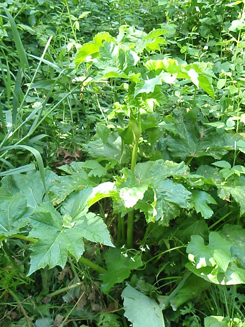
Before the flowers mature, the young stalks and leaf stems can be pealed or eaten raw or boiled like the Natives have done for centuries. The outer skin of the Cow-Parsnip contains a type of poison that can cause skin damage such as rashes, so unless you know how to handle the Cow-Parsnip, it is better to leave it alone. Due to this problem, the Cow-Parsnip is cut down along trails in the Oregon State Park System to keep visitors safe.

Cow-Parsnip at Sarah Helmick State Park
Before the flowers mature, the young stalks and leaf stems can be pealed or eaten raw or boiled like the Natives have done for centuries. The outer skin of the Cow-Parsnip contains a type of poison that can cause skin damage such as rashes, so unless you know how to handle the Cow-Parsnip, it is better to leave it alone. Due to this problem, the Cow-Parsnip is cut down along trails in the Oregon State Park System to keep visitors safe.
Monday, May 13, 2013
Weekly Dose of Oregon #1
In an effort to include other aspects of Oregon, such as lakes & beaches, I decided to create this new weekly post that provides an extra dose of Oregon. For this week's dose of Oregon, I present you with Diamond Lake. This 3,000+ acre lake has a maximum depth of just over 50 feet. While the lake is not in the shape of a diamond, (it was named after John Diamond) the lake is still a jewel of the Oregon Cascades nonetheless. Situated in a valley between Mount Thielsen and Mount Bailey, this high-mountain lake is stocked yearly with Rainbow Trout. Many campgrounds and cabins are located around the lake, along with a lodge and tackle store.


Diamond Lake with Mount Bailey behind it. The docks are not yet put in the water.

Bald Eagles have recently came back to Diamond Lake after many decades.
Mountain View Monday #7
Finally, I have some pictures of other mountains! Today's Mountain View Monday features Mount Thielsen and it's reflection in Diamond Lake. Mount Thielsen is a short distance away from the north gate of Crater Lake National Park. Since this volcano has been deeply weathered to show it's volcanic neck, geologsts believe it to be extinct. Called the 'Lightning rod of the Cascades,' Mount Thielsen get struck by lightning many times each year. When the lightning strikes the mountain, it changes the properties of the rick into Lechatelierite, a variation of Fulgerite. For many years now, I have been wanting to climb the mountain to get a sample of one of these Fulgerite rocks. As one of my favorite mountains due to its unique shape, I never get bored of seeing it's picture.


Thursday, May 9, 2013
Trail Talk Thursday #8
Just south of Aumsville (that little town between Salem and Stayton that has a skateboard park) is a county park with a trail looping through it. That trail, which has no name, winds this way and that around Young Lake in the Aumsville Ponds County Park. Besides viewing Young Lake from several spots, the trail, which I will call Young Lake Trail, also allows hikers to view two small ponds which also do not have a name. If you are lucky, like I was the day I went hiking on this trail, you might see deer and uncommon birds, such as the Red-winged Blackbird. Other birds that were seen there included a Great Blue Heron, Canadian Geese, and many smaller birds that like to hide in the marshes.


So if you're looking for a short hike within 30 minutes of Salem, check out either the trail around Young Lake at Aumsville Ponds County Park. The parking is on the north side of the park - off of Bates Road. Until next time, get outside and and enjoy hiking on one of the many trails in the great Oregon Outdoors.

The trail starts out here (parking is off to the left, Young Lake is on the right)

One of the small ponds that is along the trail

Another small pond...

Young Lake (the bridge on the other side is part of the trail)

Young Lake (you can just see the second foot bridge on the other side)

A Great Blue Heron was standing near the first bridge
So if you're looking for a short hike within 30 minutes of Salem, check out either the trail around Young Lake at Aumsville Ponds County Park. The parking is on the north side of the park - off of Bates Road. Until next time, get outside and and enjoy hiking on one of the many trails in the great Oregon Outdoors.
Tuesday, May 7, 2013
Native Talk Tuesday #7
The plant featured in today's Native Talk Tuesday is Camasia quamash,
commonly known as the Common Camas. This perennial herb, which develops from a small bulb, has numerous grass-like leaves. Due to it's distinct flowers, and abundance in the Willamette Valley, it is quite easy to spot - at least in Spring. The Common Camas is often found along the roadsides and in natural areas of western Oregon and southwestern Washington. Occurring at low to middle elevations, it is
quite common in the Willamette Valley. Depending on elevation, sunlight, temperature, and latitude
(how far north you are), the Common Camas blooms from April to May.

Camas bulbs were planted by the Kalapuya natives at many sites in the Willamette Valley as the bulbs were later consumed during or right after flowering. After steaming in large pots for a day to make the Camas bulbs more palatable, they were used to sweeten other foods and eaten right away, or even sun dried for storage or trade. Meriwether Lewis observed what happens when ingested in large quantities, "Assuredly they produce flatulence: when in the Indian hut I was almost blown out by strength of wind." If you feel like steaming some Camas bulbs to eat yourself, make sure you are taking the bulbs from the Common Camas; as the Meadow-Death Camas (which has white flowers) are highly toxic and potentially fatal.

Champoeg State Park has many Common Camas (photo above) near the visitor center.
Camas bulbs were planted by the Kalapuya natives at many sites in the Willamette Valley as the bulbs were later consumed during or right after flowering. After steaming in large pots for a day to make the Camas bulbs more palatable, they were used to sweeten other foods and eaten right away, or even sun dried for storage or trade. Meriwether Lewis observed what happens when ingested in large quantities, "Assuredly they produce flatulence: when in the Indian hut I was almost blown out by strength of wind." If you feel like steaming some Camas bulbs to eat yourself, make sure you are taking the bulbs from the Common Camas; as the Meadow-Death Camas (which has white flowers) are highly toxic and potentially fatal.
Sunday, May 5, 2013
Now anyone can post a comment.
After receiving a tip on making my blog more readable, I began checking other settings and found out, to my annoyance, that I had a default setting that wouldn't allow every reader the chance to comment. As that is now fixed, everyone can comment on this blog. If you have an idea for my blog, Ill see what I can do.
While I post this, I figure I might as well take the time to tell you about the posts on this blog. Some of you may have noticed that I don't post an article about a state park or whatnot every week. There are two main reasons for this:
1 - I do not have the pictures/information on whatever it is. When it comes to a state park or trail, I like to research about the park and take my own pictures. As for a native plant or animal or even a waterfall, I want to get my own picture at the time of year I think it is at it's best - that is flowers are best when blooming, deciduous trees look great in late October, and a great waterfall picture depends on the surrounding vegetation (except during wintertime when snow and ice are what determines the waterfall picture)
2 - I have limited time and money. While I would love to be in one corner of the state one week and a different corner the next, I just do not have the money for multi-day trips every week, nor do I have a job that I can schedule things around. I work at a mobile slaughter, which means I work when I can. From January to June I have the time but not the money to check out state parks, while the other have of the year, I will have the money but not the time.
To those that keep reading my blogs, thank you for staying with me. As I said above, If you have an idea for me, I'll see what I can do.
Earth Speak Sunday #7
 Henry David Thoreau
The birds I heard today, which, fortunately, did not come within the scope of my science, sang as freshly as if it had been the first morning of creation.
Friday, May 3, 2013
Festival Friday #5
Here in the Willamette Valley, we have many types of festivals throughout the year. Some of these are very well known (Oktoberfest), while some of these are not (Wurstfest). For this Festival Friday, I would like to mention a festival that I had not heard of until last summer. The Linn County Lamb & Wool Fair in Scio, Oregon, will be celebrating its 78th year from May 17th to the 19th.
This fair features sheep shows, fiber arts, and crafts. Northwest Champion Sheepdog Trials will be held at the same time. On Saturday the 18th, a parade will be held, and those with baking skills can enter for a Chocolate Cake Contest. Many other events occur over the three days, and certain events only occur once, so check the website listed below to find out which day you would like to check out this festival.
You can also check out their website, Northwest Lamb & Wool Fair, for more information.
Thursday, May 2, 2013
Trail Talk Thursday #7
If you are looking for a short hiking trail like no other here in the Mid-Willamette Valley, you really do not have to look far. Just south of Salem, the Ankeny National Wildlife Refuge has several trails that get you off the ground and on a boardwalk that takes you through the trees and over streams to bird viewing blinds that allow hikers to watch birds without disturbing them. The Rail Trail takes hikers on a boardwalk through an Oregon Ash Wetland, while the Pintail & Egret Marsh Boardwalk takes hikers through a lowland forest to the Pintail and Egret Marshes. It is here along this boardwalk where you can here the birds calling through the woods as the trail meanders left and right through the trees before coming into the open marshes at the observation area. For those that come at the right time, you may be able to see some of the amphibians that inhabit the region, but you have to be quiet if you want to see them.

So if you're looking for a short bird-watching hike in the mid-Willamette Valley, check out either the Rail Trail or the Pintail & Egret Marsh Boardwalk at the Ankeny National Wildlife Refuge. Until next time, get outside and and enjoy hiking on one of the many trails in the great Oregon Outdoors.

The Pintail & Egret Marsh Boardwalk
So if you're looking for a short bird-watching hike in the mid-Willamette Valley, check out either the Rail Trail or the Pintail & Egret Marsh Boardwalk at the Ankeny National Wildlife Refuge. Until next time, get outside and and enjoy hiking on one of the many trails in the great Oregon Outdoors.
Subscribe to:
Comments (Atom)